Strengthening Immunization Services with GIS-Based Digital Microplanning Training in Malawi
As part of its commitment to health systems strengthening, CIPHER, in collaboration with the Ministry of Health, UNICEF and Luke International, has successfully trained over 150 frontline health care workers in GIS-based digital microplanning across five districts in Malawi. This innovative training initiative is a critical step toward reversing declining immunization coverage and ensuring equitable vaccine delivery to every child—especially in underserved and hard-to-reach areas.
Geographic Information Systems (GIS) are powerful digital tools that allow users to capture, visualize, and analyze spatial data. In public health, GIS has emerged as a game-changer—especially in immunization programs—by enabling data-driven decision-making and more targeted service delivery.
In Malawi and other low- and middle-income countries, traditional microplanning methods have often relied on outdated maps, estimations, and manual data, making it difficult to reach zero-dose children and underserved areas effectively. GIS tools address these gaps by providing accurate, real-time spatial intelligence to guide planning and resource allocation.
This tool, when used in combination with the Rapid pro technology, a digital tool for real-time immunization data reporting significantly strengthens the program’s overall capacity to monitor coverage, address gaps swiftly, and adapt strategies as necessary.
The implementation strategy adopted a phased approach to ensure systematic capacity-building and operationalization of GIS-based immunization microplanning. 5 districts have been targeted but the implementation commenced in three districts namely: – Nkhatabay, Salima, and Mwanza. Following this, the focus shifted to Balaka and Ntchisi districts where the trainings have also been conducted.
- Train participants to use QGIS software for mapping, planning, and analyzing immunization data.
- Build capacity to develop and implement data-driven micro plans tailored to local contexts.
- Familiarize participants with digital tools for accurate recording, reporting, and management of Expanded Program on Immunization (EPI) data.
- Enable health workers to identify underserved areas and optimize immunization outreach to improve vaccine access and equity
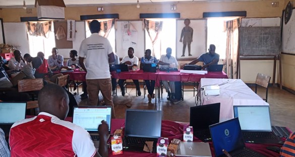
Training Sessions
The training used a blend of theory and practical sessions as well as group work. The training content focussed on:
The digital microplanning training was conducted by a team of expert trainers CIPHER, IT specialists, GIS experts from LIN, and the national Expanded Program on Immunization (EPI) team. The training was designed to be highly interactive and hands-on, ensuring participants developed practical skills essential for implementing GIS-based immunization microplanning.
To maximize learning, the training incorporated real-world applications through a variety of exercises, including drawing physical maps, digitizing them into GIS formats, engaging in group activities, and completing individual assessments to track progress. This approach ensured that participants not only gained technical proficiency in GIS tools but also understood how to apply these skills in immunization microplanning to improve service delivery. Modules covered include:
- Basic Computer Skills: Foundational computer skills, including navigation, file management, and software use.
- Introduction to GIS and QGIS: Overview of Geographic Information Systems (GIS) and the QGIS platform, focusing on applications in immunization microplanning. Additionally, the session proceeded to highlight on mapping health facility catchment areas, analyzing spatial data, and identifying underserved zones.
- Digital Microplanning Activities: focussed on mapping exercises, routine optimization, and data analysis.
- Group Exercises and Practical Applications: included simulated real-world scenarios, and group exercises for practical purposes.
- Assessments: pre- and post-training assessments were done to evaluate learning progress.
Digital Microplanning Process and Activities
- Mapping Health Facility Catchment Areas
Participants first created physical maps representing health facility catchment areas and immunization routes. These maps were then digitized using QGIS, allowing participants to learn how to convert manual maps into GIS formats for dynamic analysis and adjustments.
- GIS-Based Microplanning
Using GIS tools, participants designed detailed immunization micro plans, optimizing service delivery by:
- Identifying immunization points
- Planning routes for maximum coverage and accessibility
- Group Exercises and Practical Applications
Participants engaged in collaborative microplanning activities, applying their GIS skills in realistic scenarios. Trainers provided technical support and guidance, ensuring participants could troubleshoot challenges and effectively use GIS tools in the field.
- Pre-Test and Post-Test Assessments
To measure knowledge acquisition, participants completed:
- A pre-test to establish their baseline understanding
- A post-test to assess progress and identify areas for further support
Results from these assessments guided individualized feedback and helped tailor ongoing capacity-building efforts.
- Plenary Discussions and Feedback Sessions
At the end of each module, trainers facilitated plenary discussions, allowing participants to:
- Ask questions and clarify concepts
- Share insights and best practices
- Provide feedback for continuous improvement
These sessions encouraged peer learning and helped participants refine their understanding of GIS-based immunization microplanning.
The training yielded several these outcomes:
- Enhanced GIS Proficiency: A total of Outcome of over 150 participants, including HSAs and other health personnel from 63 health facilities have been trained acquiring practical skills in using QGIS for immunization microplanning.
- Improved Targeting of Underserved Areas: Health workers are now better equipped to identify and prioritize high-risk communities.
- Strengthened Data Management: Participants gained proficiency in digital data collection, reporting, and analysis, enabling more responsive decision-making.
- Capacity-Building at the District Level: District officers and health facility staff are now empowered to lead the implementation of GIS-based strategies in their respective areas.
The following steps are critical to sustaining and scaling up these efforts:
- Operationalization of Outreach Clinics: Integrated Services: Establish integrated outreach clinics to address gaps identified through GIS mapping. Additionally, these clinics will provide immunization, antenatal care, growth monitoring, and village clinic services.
- Monitoring and Evaluation: Regular field visits and assessments will ensure the effectiveness of the GIS-driven microplanning strategy and identify areas for improvement.
- Scale-Up to Additional Districts: Expand the program to other districts based on lessons learned from the implementing districts.
- Ongoing Support and Mentorship: Provide continuous mentorship to trained health workers to reinforce skills and address challenges in implementation.